
搜索到
8
篇与
的结果
-
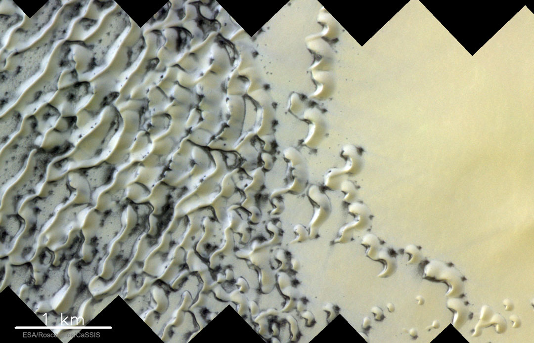
 2019年09月24日:火星解冻的沙丘-(Sand Dunes Thawing on Mars) 2019年09月24日:火星解冻的沙丘-(Sand Dunes Thawing on Mars)--原图下载{mtitle title="火星解冻的沙丘"/}Image Credit & License: ESA, Roscosmos,CaSSIS说明: 火星上这些奇特的形状是什么?是正在解冻的沙丘。随着春天降临火星的北半球,上面这片由欧洲航天局.火星微量气体任务卫星,在今天5月底拍摄的近北极沙丘,就开始解冻。在稀薄的大气环境中,乾冰(冻结的二氧化碳)和水冰直接昇华成气体。冰较薄的区域,通常先解冻,而曝露出的沙,因为色泽较深,在阳光中吸热较快,更加速冰消融的速率。解冻的过程中,甚至可能出现穿破薄冰的沙喷流。当夏天来临时,融解区将扩及整片沙丘。火星的北极周围环绕着许多类似的新月形沙丘,它们奇特平滑的形状,是受到永不停歇的火星风之雕塑。(ExoMars Trace Gas Orbiter,TGO or ExoMars Orbiter 火星微量气体任务卫星){lamp/}原文:{mtitle title="Sand Dunes Thawing on Mars"/}Image Credit & License: ESA, Roscosmos,CaSSISExplanation: What are these strange shapes on Mars? Defrosting sand dunes.As Spring dawned on the Northern Hemisphere of Mars, dunes of sand near the pole, as pictured here in late Mayby ESA's ExoMars Trace Gas Orbiter, began to thaw. The carbon dioxide and water ice actually sublime in the thin atmosphere directly to gas. Thinner regions of ice typically defrost first revealing sand whose darkness soaks in sunlight and accelerates the thaw. The process might even involve sandy jets exploding through the thinning ice. By Summer, spots will expand to encompass the entire dunes. The Martian North Pole is ringed by many similar fields of barchan sand dunes, whose strange, smooth arcs are shaped by persistent Martian winds.
 -
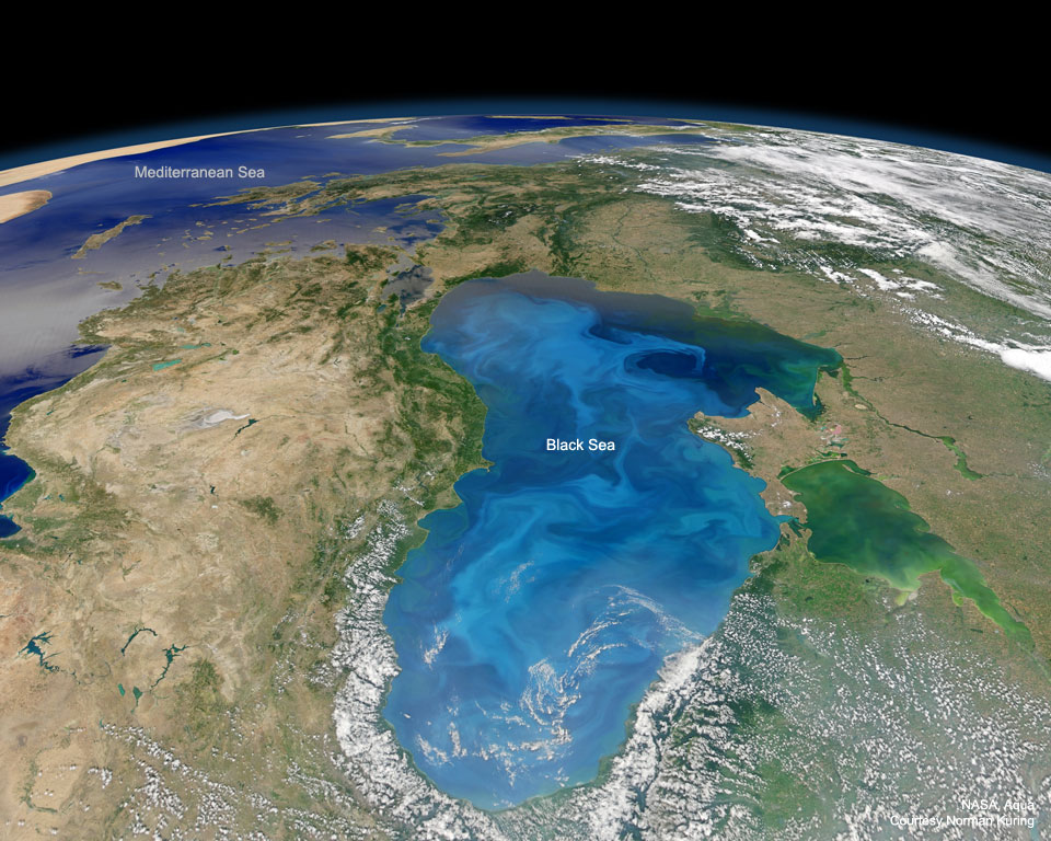
2017年04月24日:黑海的白色战役-(A White Battle in the Black Sea) 2017年04月24日:黑海的白色战役-(A White Battle in the Black Sea)--原图下载{mtitle title="黑海的白色战役"/}Image Credit: NASA, Aqua, MODIS说明: 数十兆的生命葬身在地球的海洋里。而部分死者的钙化盾牌,叠出了多佛的白色悬崖。球形淡色的单细胞植物、名为球菌藻的浮游植物和更小钻石状病毒、名为藻类去氧核糖核酸病毒的战斗,持续了数千万年。为了进行备战,球菌藻吸收了大气里的二氧化碳来製作白垩盔甲。这场战役的规模是如此之庞大,以至于球菌藻移走了地球大气中大量的二氧化碳,从而提供适合包括人类在内的动物呼吸的空气。在这幅由美国航太总署水卫星所拍摄的2012年影像里,黑海因球菌藻华而变成淡蓝色。{lamp/}原文:{mtitle title="A White Battle in the Black Sea"/}Image Credit: NASA, Aqua, MODISExplanation: Trillions have died in the Earth's seas.Calcified shields of the dead already make up the white cliffs of Dover.The battle between ball-shaped light-colored single-celled plants -- phytoplankton called coccolithophores -- and even smaller, diamond-shaped viruses dubbed coccolithoviruses -- has raged for tens of millions of years. To help fight this battle, the coccolithophores create their chalky armor by absorbing carbon dioxide from the atmosphere. This battle is so epic that coccolithophores actually remove a significant fraction of Earth's atmospheric carbon dioxide, bolstering the breathability of air for animals including humans.Pictured in this 2012 image from NASA's Aqua satellite, the Black Sea was turned light blue by coccolithophore blooms.
-
2016年10月10日:地球的风-(The Winds of Earth) 2016年10月10日:地球的风-(The Winds of Earth)--原图下载2016 October 10 {mtitle title="地球的风"/}Image Credit & Copyright: Cameron Beccario,earth.nullschool.net; Data & Processing (abridged): GFS & US National Weather Service (NOAA); GEOS-5 & Goddard Space Flight Center (NASA)说明: 风往那个方向吹呢?不管你住在地球何处,这张主题图片能给你答案并提供更多的资讯。这张动态地图,呈现了超级电脑根据每3小时更新一次的多组全球卫星数据所进行之预报。明亮的涡旋通常是带着强风的低气压系统,其中包括气旋、飓风和颱风。虽然你可以旋转这幅图所呈现的地球,但如想要有包括放大与缩小在内的完整互动功能,你得点选左下角的地球字样,然后它后它会把你带到https://earth.nullschool.net。在新的图板里,鼠标点在地球的文字标示上所带出之控制板,能让你叠加上温度、溼度、压力、降水和二氧化碳的图层,甚至显示较高层的风速和洋流。在这个天气变化快速的年代。此处所呈现的图板可能很快就会过时或失真。{lamp/}原文:{mtitle title="The Winds of Earth"/}Image Credit & Copyright: Cameron Beccario,earth.nullschool.net; Data & Processing (abridged): GFS & US National Weather Service (NOAA); GEOS-5 & Goddard Space Flight Center (NASA)Explanation: Which way is the wind blowing?The featured map can tell you this and much more, no matter your location on planet Earth.The dynamic map displays supercomputer forecasts drawn from multiple sourcesof global satellite data updated every three hours.Bright swirls usually indicate low pressure systems with high wind speeds, including dramatic cyclones, hurricanes and typhoons. Although the globe can be rotated interactively here, to obtain full interactivity -- including the ability to zoom -- you should click the word "earth" on the lower left or send your browser directly to https://earth.nullschool.net. The "earth" control panel there further allows you to overlay temperature, humidity, pressure, precipitation, and carbon dioxide maps, or even switch to displaying higher altitude wind speeds or ocean currents.In particular during times of rapid change, the displayed maps may be outdated or inaccurate.
-
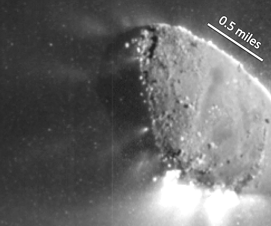
2010年11月23日:哈特利二号彗星的气体与雪球-(Gas and Snow Jets from Comet Hartley 2) 2010年11月23日:哈特利二号彗星的气体与雪球-(Gas and Snow Jets from Comet Hartley 2)--原图下载{mtitle title="哈特利二号彗星的气体与雪球"/}Credit: NASA,JPL-Caltech,UMD,EPOXI Mission说明: 发现哈特利二号的异常喷流特徵。本月初EPOXI太空船飞越彗星时,细部影像中捕捉到喷流的特徵。上述影像中,太阳使得运转于太阳地球与木星之间冰岛喷发。当哈特利二号彗星靠近太阳,受到太阳加热而活跃。初步分析,在平滑且接近中央的位置,向外太空渗透出冻结的水蒸气。然而,意外的是,在彗核的另外一端(较为粗糙处)喷出二氧化碳,并且伴随着鬆软的雪球,部分雪球甚至跟篮球一样大。这张精彩的影像中,有许多雪球造成的点点。异常的喷流研究将会持续下去,从彗星与小行星的形成与演变,能够更加了解初期的太阳系。哈特利二号彗星正缓慢的蒸发中,预计在一千年后就会彻底地消失殆尽。{lamp/}原文:{mtitle title="Gas and Snow Jets from Comet Hartley 2"/}Credit: NASA,JPL-Caltech,UMD,EPOXI MissionExplanation: Unusual jets have been discovered emanating from Comet Hartley 2.The EPOXI spacecraft imaged the jets in unprecedented detail during its flyby of the comet earlier this month. Pictured above, sun-illuminated jets shoot away from the two-kilometer long decaying iceberg that orbits the Sun between Earth and Jupiter. Comet Hartley 2 became active recently as it neared the Sun and sunlight warmed the comet.Preliminary analyses of images like that shown above indicate that the smooth regions around the middle are porous and leak frozen water vapor directly out into space. Unexpectedly, however, the rough regions at either end appear to shoot carbon dioxide jets that expel fluffy snowballs, some as large as basketballs, from the nucleus. Many of the dots in the above image are thought to be snowballs.The unusual jets will continue to be studied, and may yield further clues as to how comets and asteroids formed and evolved during the early years of our Solar System.Comet Hartley 2 is slowly evaporating and may completely break up over the next 1,000 years.
-
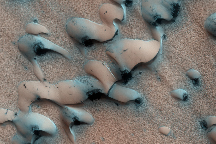
2008年03月03日:火星上融化中的砂丘-(Sand Dunes Thawing on Mars) 2008年03月03日:火星上融化中的砂丘-(Sand Dunes Thawing on Mars)--原图下载{mtitle title="火星上融化中的砂丘"/}Credit: HiRISE, MRO, LPL (U. Arizona), NASA说明: 火星上这些外型怪异的东西是什么?它们是融化中的砂丘。随着春天降临火星的北半球,如上面这张照片,北极附近的砂丘开始融化。 二氧化碳和水冰会直接升华成气体,飘至稀薄的大气层中。冰层较薄的地方通常会较早解冻,而这些黑色的砂丘浸泡在阳光会加速冰层的融化。融化的过程中,甚至可能会有气砂喷流穿过薄冰。夏天时, 这些小点会扩大至整个砂丘。火星的北极周围围绕着许多类似的新月砂丘,这些弧型结构是由火星上的风所造成的。{lamp/}原文:{mtitle title="Sand Dunes Thawing on Mars"/}Credit: HiRISE, MRO, LPL (U. Arizona), NASAExplanation: What are these strange shapes on Mars? Defrosting sand dunes.As spring now dawns on the Northern Hemisphere of Mars, dunes of sand near the pole, as pictured above, are beginning to thaw. The carbon dioxide and water ice actually sublime in the thin atmosphere directly to gas. Thinner regions of ice typically defrost first revealing sand whose darkness soaks in sunlight and accelerates the thaw. The process might even involve sandy jets exploding through the thinning ice. By summer, spots will expand to encompass the entire dunes. The Martian North Pole is ringed by many similar fields of barchan sand dunes, whose strange, smooth arcs are shaped by persistent Martian winds.
-
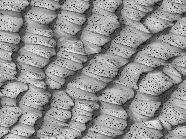
2004年08月31日:火星的点状沙丘-(The Dotted Dunes of Mars) 2004年08月31日:火星的点状沙丘-(The Dotted Dunes of Mars)--原图下载{mtitle title="火星的点状沙丘"/}Credit & Copyright: Malin Space Science Systems,MOC,MGS,JPL, NASA说明:是什么因素产生火星上的点状沙丘? 当春天降临火星的北半球时,靠近极区的沙丘便开始融化。 冰较薄的地区通常会首先融化而露出沙丘,而这些黑色的沙丘在阳光下又会吸收热量,加速冰层的融化。到了夏天,这些小点将会逐渐扩大到整个沙丘变成黑色,而冰层则完全消融。 二氧化碳和冰则直接昇华到稀薄的大气层中。 七月中,在靠近火星北极的地方,上面的影像长宽约三公里,展现的是这些位于极区带着斑点的沙丘的一部份。在此同时,火星的南半球,来自地球的无人火星探测车即将面对火星九月中旬的隆冬并试着存活下去。{lamp/}原文:{mtitle title="The Dotted Dunes of Mars"/}Credit & Copyright: Malin Space Science Systems,MOC,MGS,JPL, NASAExplanation: What causes the black dots on dunes on Mars? As spring dawns on the Northern Hemisphere of Mars, dunes of sand near the poles begin to defrost. Thinner regions of ice typically thaw first revealing sand whose darkness soaks in sunlight and accelerates the thaw. By summer, the spots will have expanded to encompass the entire dunes that will then be completely thawed and dark.The carbon dioxide and water ice actually sublime in the thin atmosphere directly to gas. Taken in mid-July, the above image shows a field of spotted polar dunes spanning about 3 kilometers near the Martian North Pole. Meanwhile, in the Southern Hemisphere of Mars, the Earth-sent robot Martian rovers will try to survive through Martian winter, which peaks in mid-September.